Encroachment Through Incompatible Land Use
When Growth Meets the Ground
Camp Atterbury’s protected interior has remained largely intact since 1942, but the landscape at its edges tells a different story. Over eight decades, rural farmland and forests have gradually transformed, with homes, roads, and industrial corridors extending closer to training lands and wildlife habitat.
This section combines two lenses, encroachment and incompatible land use, to examine how development patterns are reshaping the region and what those changes mean for the broader landscape. These shifts influence several interconnected outcomes:
- Training readiness: changes in surrounding land use can affect how and where training activities occur.
- Habitat integrity: landscape fragmentation can alter connectivity for wildlife and ecological systems.
- Community resilience: development patterns can influence long-term environmental conditions, including water, land, and infrastructure.
Together, these patterns provide context for understanding how land use change shapes conditions around Camp Atterbury over time.
Before diving into the data, it helps to clarify what these terms mean in practice and why they matter for both defense and conservation.
According to the Readiness and Environmental Protection Integration (REPI) program, encroachment is any external factor that inhibits military readiness, including but not limited to the growing competition for land, airspace, waterfront access, and frequency spectrum.
Incompatible land uses can impact critical, at-risk military mission capabilities at different scales over time. Increasingly, land uses far away from the installation and range boundaries can also have an impact on the military's ability to train, test, and operate.
Around Camp Atterbury, encroachment is reflected in several land use patterns, including suburban growth along the Greenwood-Franklin-Edinburgh corridor, annexations near Columbus, and low-density rural housing in Brown County's forested areas. Encroachment itself is not inherently negative. It becomes a compatibility challenge when development patterns intersect with areas important for training, public safety, habitat, floodplains, or groundwater protection.
Incompatible land use occurs when development patterns or infrastructure undermine training capability, environmental quality, or public safety. This includes new homes or schools near live-fire or flight zones, as well as residential and commercial development into floodplains or areas known to support sensitive species such as bat habitat.
Per REPI, development near military areas can restrict training, testing, and operating in many ways, including:
- Night-vision training disruption: Lights from residential and commercial development reduce the effectiveness of night-vision training
- Noise complaints: Complaints about noise, dust, and smoke generated by military activities result in restrictions on the timing, frequency, and type of training activities
- Frequency spectrum competition: Competition for frequency spectrum interferes with mission readiness
- Infrastructure conflicts: Communication towers, wind turbines, highways, and energy transmission lines near or through training areas all hinder realistic training and testing
- Habitat displacement: Land development that destroys or fragments endangered species habitat pushes those species onto less developed military lands, resulting in increased restrictions on training and testing land
These patterns become clearer over time. Rather than a single shift, encroachment reflects decades of landscape change shaped by infrastructure, growth corridors, local planning decisions, and changing land values.
1940s-1960s: Establishment and Early Decades
- Camp Atterbury was established in 1942 on roughly 40,000 acres spanning Johnson, Bartholomew, and Brown Counties.
- Dozens of farmsteads, small communities, and schools were displaced, transforming a rural agricultural mosaic into a structured military training landscape.
- The surrounding region remained dominated by cropland and forest, with limited population density and minimal land subdivision.
- Incompatible land use was virtually nonexistent. Rural livelihoods, forest buffers, and training operations coexisted with little interference, as illustrated in the swipe map's aerial view.
- Brown County's heavily forested terrain served as a natural buffer between the installation and surrounding towns.
1970s-1990s: Suburban Creep Southward
- As Indianapolis expanded south, early suburban corridors formed along US-31 and I-65 in Johnson and Bartholomew Counties, replacing farmland with residential subdivisions.
- Farmland fragmentation accelerated near Franklin, Whiteland, and Edinburgh. These linear corridors would later become long-term encroachment vectors.
- Brown County remained over 90% forested, but private lake communities such as Prince’s Lakes and Cordry–Sweetwater introduced amenity-driven rural development. As shown in the 1980–today land-use swipe map (and further detailed in the Cordry–Sweetwater Case Study), these early clusters marked significant breaks in the county’s continuous forest cover.
- Septic permits began increasing in unsewered areas, marking early signs of forest fragmentation. While compliant, their clustering indicated growth pressure in sensitive terrain.
- Atterbury's perimeter buffers were still largely intact, but future encroachment patterns were taking shape along transportation corridors.
2000s-2010s: A Landscape Transformed
- Residential and industrial expansion intensified along I-65 and US-31, converting farmland into suburban and commercial corridors and extending development outward from existing urban centers.
- Impervious surface expanded substantially from 2001 to 2010, altering stormwater runoff patterns. These changes can increase flooding risk, strain drainage systems, and affect access to training areas north of Camp Atterbury.
- Subdivisions increasingly overlapped mapped bat habitat, floodplains, and groundwater recharge areas, marking the growing presence of incompatible land use across the landscape.
- Bartholomew County's west-side annexations near SR-46 extended development toward riparian corridors that had previously functioned as natural buffers.
- The interactive map tool allows you to explore how land cover has changed over time across the Camp Atterbury landscape.
2010s-2020s: The Current Pulse of Conversion
- Farmland conversion has continued across the region. Indiana lost an estimated 1.5-2% of agricultural land between 2010 and 2022 due to industrial, residential, and commercial development (ISDA, 2024).
- Johnson County has experienced sustained growth, where suburban and industrial zoning has reduced portions of the agricultural buffers north of Camp Atterbury.
- Septic and building permits in Brown County indicate ongoing low-density forest subdivision, contributing to gradual but meaningful landscape fragmentation.
- Development along SR-46 and US-31 increasingly overlaps flood-fringe zones and wetland buffers. These patterns may influence long-term flood management, environmental conditions, and access to nearby training areas.
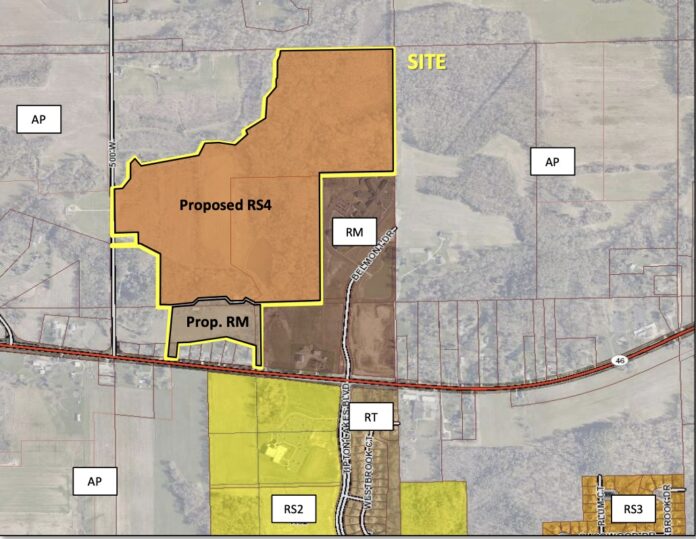
- The SR-46 Chase Point rezoning proposal provides a recent example of this pattern and is highlighted in the swipe map.
2040 & Beyond: Planning for Compatibility
- Farms Under Threat 2040 projects continued development along the Greenwood, Franklin, and Edinburgh corridor under current land use trends, particularly without coordinated zoning and conservation strategies.
- Continued residential and industrial growth may reduce compatible-use buffers, influence habitat connectivity for bat and bird species, and increase overlap with night-training areas.
- Land-use modeling suggests that targeted conservation easements, compatible-use zoning overlays, and rural growth boundaries could retain over 20% additional open space by 2050 compared to business-as-usual scenarios.
- Planning approaches that integrate the Southern Indiana Sentinel Landscape partnership, REPI conservation tools, and other agricultural land protections can support more coordinated outcomes, including clustered development, groundwater protection, and forest connectivity.
Encroachment Risk
Development pressure around Camp Atterbury’s perimeter has not occurred evenly. The north and northeast show the strongest encroachment risk due to suburban and corridor-based growth. The east and southeast show moderate expansion linked to development near transportation corridors, while the west and southwest remain comparatively stable because steep, forested terrain has limited residential subdivision activity.
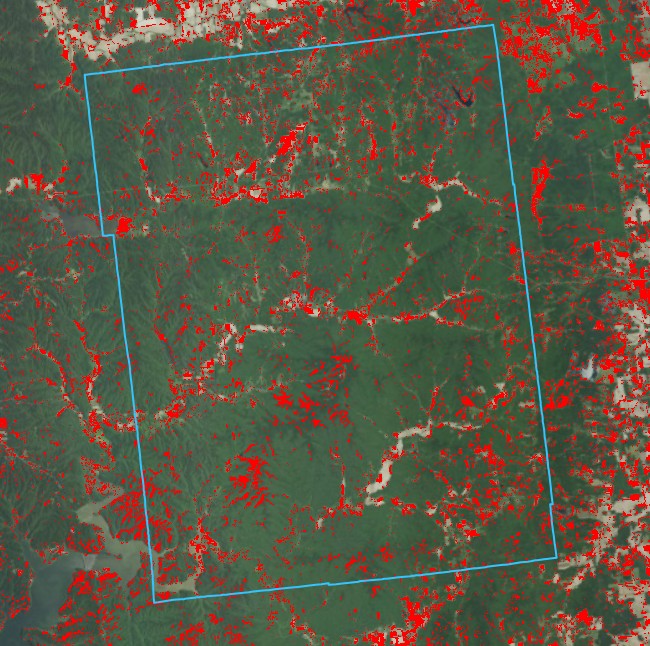
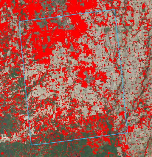
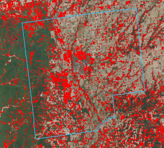
Understanding this pattern requires examining how surrounding landscapes have changed over time. The EVA (Enhanced Visualization and Analysis) tool reveals how development has evolved from 1985–2024 across Brown, Johnson, and Bartholomew Counties, the three counties that most strongly shape encroachment patterns around Camp Atterbury.
Source: Multi-Resolution Land Characteristics (MRLC) Consortium, National Land Cover Database (NLCD)
Brown County
Johnson County
Bartholomew County
Growth in Numbers, Signals of Change
The EVA findings illustrate where development pressure is occurring, but long-term demographic and land-use trends help explain why these patterns have emerged. Over the last several decades, population growth, increasing septic density, and gradual land conversion have reshaped the landscape surrounding Camp Atterbury.
As counties north and northeast of the installation have urbanized, development has expanded south from Indianapolis in Johnson County, outward from Columbus in Bartholomew County, and into the amenity-driven uplands of Brown County. These trajectories mirror the EVA development patterns shown above and highlight how encroachment pressure has increased along specific portions of the installation boundary over time.
In rural, unsewered areas, especially Brown County, new septic permits provide early indicators of forest fragmentation and low-density subdivision growth. Because this form of development often preserves forest canopy, it may not be fully captured in satellite-based land-cover datasets. As a result, septic permit density can serve as an early signal of emerging development patterns, often appearing years before land cover change is detectable.
The interactive map below visualizes septic permit locations and timing across Brown County from 1960 to present (2025), allowing you to explore how these patterns have developed across the landscape.
Septic permit locations over time highlight low-density development within forested areas of Brown County that is not readily captured by land-cover imagery. Source: Brown County Administration
The spatial legacy of decades of permit activity remains visible across Brown County's landscape, with concentrations in amenity-driven uplands and along forest edges. This pattern of incremental, low-density subdivision has contributed to changes in compatible-use buffers around Camp Atterbury, creating conditions where development patterns more frequently intersect with training operations and sensitive habitat.
Training Readiness and Habitat Integrity
As development moves closer to Camp Atterbury, the landscape around the installation becomes more complex to manage. These changes can affect both the day-to-day function of Camp Atterbury’s training environment and the surrounding ecological systems. The impacts fall into two connected dimensions: training readiness and habitat integrity.
- Encroaching residential and commercial development increases noise and light conflicts, leading to more community complaints and operational restrictions.
- Reduced night-training and range flexibility as safety buffers expand and incompatible land uses (such as industrial, residential, and commercial development) move closer to training areas.
- Loss of rural buffer and natural terrain fragments maneuver corridors, limits large-scale exercises, and erodes the isolation needed for realistic training.
- Farmland and forest conversion transforms natural buffers into suburban development, increasing habitat isolation and fragmenting ecosystems surrounding the installation.
- Disrupted landscape connectivity limits movement corridors and foraging habitat for bats, migratory birds, and other wildlife species.
- Expanding development edges intensify light, noise, and invasive-species pressures along the installation boundary.
Compatibility Zones: Where Growth Meets Sensitivity
The readiness and habitat considerations described above become most apparent where development patterns overlap with Camp Atterbury's operational buffers and sensitive ecological features. Drawing from the EVA analysis, demographic trends, and field observations, three compatibility zones emerge, each shaped by different development patterns and presenting distinct planning considerations.
The table below summarizes these county-level patterns, highlighting where growth pressure and environmental sensitivity intersect most strongly.
| County | Primary Pressures | Compatibility Concerns |
|---|---|---|
| Johnson | Rapid suburban & industrial expansion along I-65, US-31, and State Road 252 | Noise-sensitive training buffers and flooding exacerbated through increased impervious areas from development. |
| Bartholomew | Annexations and corridor-edge growth along and north of SR-46 | Moderate risk west of Columbus |
| Brown | Low density rural housing expansion | Water-quality risk, forest fragmentation, and priority species habitat loss |
Planning for Balance
Encroachment and incompatible land use are not fixed outcomes. They are shaped by local and regional planning decisions over time. By aligning zoning, conservation, and infrastructure planning with compatible-use principles, Indiana can support both community growth and national defense readiness.
A balanced approach requires coordination among communities, conservation partners, and defense stakeholders so that development, natural resources, and military training needs can be considered together.
Key Actions
- Prioritize conservation easements in undeveloped buffer areas around Atterbury
- Encourage planning and zoning approaches that support long-term land use compatibility
- Support Southern Indiana Sentinel Landscape as a leader in integration of defense, agriculture, and conservation.
Looking Toward 2050
Camp Atterbury’s landscape will continue evolving. The question is not whether growth will occur, but how well it will coexist with the missions and habitats that define this place. Through data-driven mapping, historic land records, and forward-thinking policy, Indiana can build a future where growth and stewardship align rather than collide.